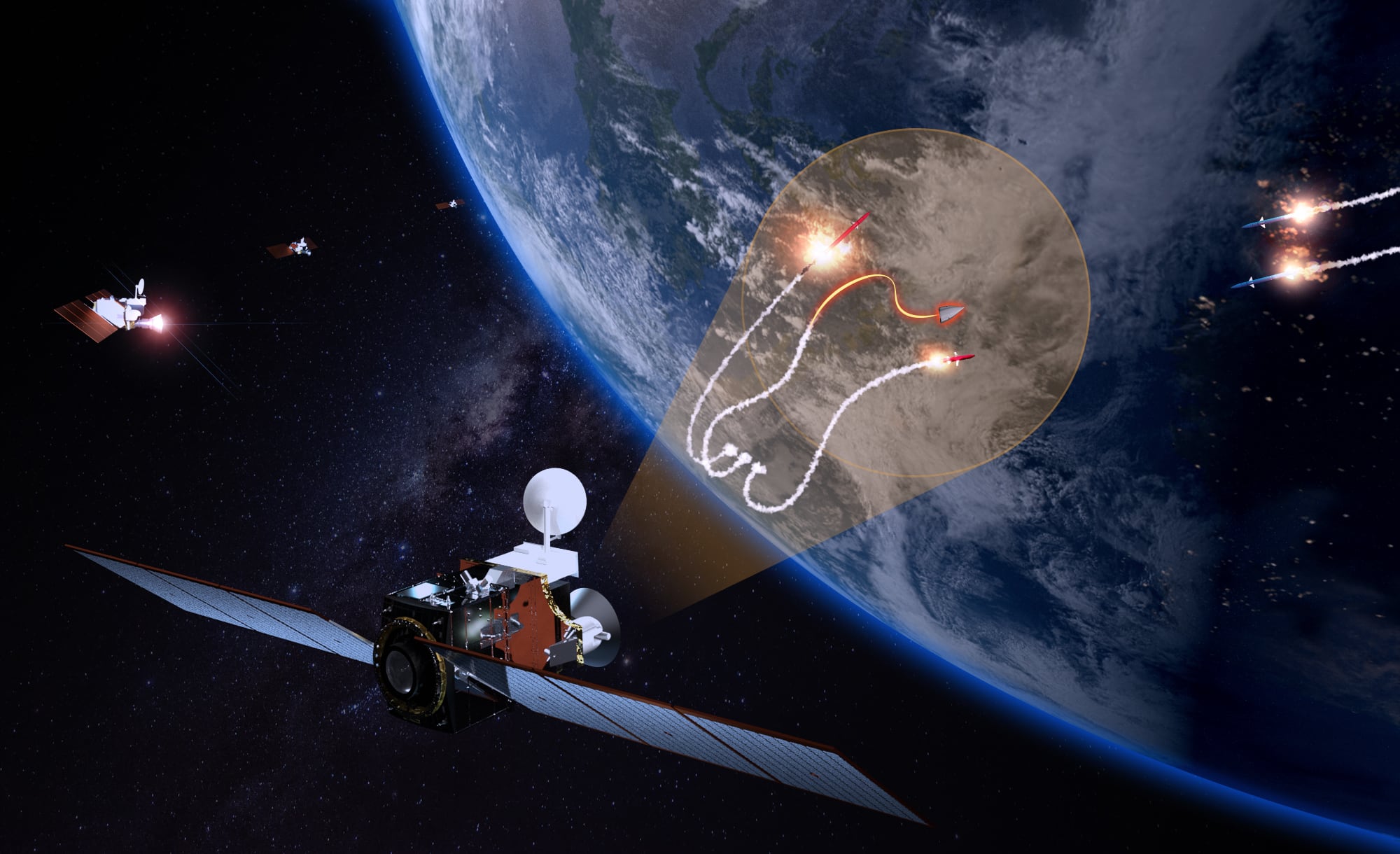
WASHINGTON — For decades, the United States has used the same approach to detecting ballistic missiles from space: Put a handful of satellites with infrared sensors high in orbit and spread them out to achieve 24/7 coverage of the Earth’s surface.
And it’s largely worked. The Space Force tracks thousands of missiles a year, and in one high-profile case in 2020, America’s premier missile detection satellite system was credited with giving a last-minute warning to war fighters in Iraq who were able to seek shelter from incoming missiles launched from Iran.
But that constellation structure is no longer sustainable. The proliferation of anti-satellite weapons is challenging the approach. It no longer makes sense, U.S. military leaders have said, to put all of their billion-dollar eggs in one basket.
What the Space Force wants is a distributed architecture, meaning more satellites for each capability that are layered in different orbits. Instead of just having a few missile warning satellites in geostationary orbit at 22,236 miles above the Earth’s surface, the service wants to place some in medium Earth orbit — the area from 1,243 miles above Earth up to geostationary orbit.
RELATED
Meanwhile, the Space Development Agency is developing a new constellation that will also track missiles, made of hundreds of satellites closer to the surface in low Earth orbit. Those are to start operating years before the Space Force could expand its missile warning system.
That sort of distributed architecture across the three levels of orbit not only would offer flexibility; it would ensure adversaries can’t knock America’s space capabilities offline by disabling or destroying a single satellite. If the satellites in geostationary orbit aren’t available, the Space Force can rely on satellites in other orbits.
Now, digital engineering tools are giving Space Force officials new insight into how to achieve that distributed architecture to augment high-orbit satellites that watch for missiles. The service is heavily investing in digital engineering concepts that have made headway in parts of the aerospace community and other industries, enabling it to test and validate new satellite designs and constellation structures in a digital environment. More than simply providing graphics, the tools allow users to test their designs in simulations that accurately represent space environments, and track how changes affect performance.
America’s next missile warning constellation — the Next Generation Overhead Persistent Infrared — was designed as one of those large, exquisite systems with sophisticated, expensive technology. The first block will comprise five satellites placed in high orbit, effectively replacing the Space Based Infrared System satellites in a like-for-like move with some small changes. The Space and Missile Systems Center awarded Lockheed Martin $2.9 billion in 2018 to design three geostationary satellites, and $4.9 billion in 2021 to build them. Northrop Grumman secured $2.4 billion to design the constellation’s two polar satellites.

But in May, the Space Force announced two contracts that could radically change the future of the system. The SMC issued two awards — $29 million for Raytheon Technologies and about $28 million for Millennium Space Systems, a Boeing subsidiary — to build digital models of the next generation of Next Gen OPIR satellites. The companies will use digital engineering practices not only to design the satellites, but to validate whether they can effectively operate in medium Earth orbit.
A transition to MEO satellites would be a seismic shift for America’s missile warning architecture, and the move to use digital engineering provides one of the first looks at what the Space Force meant when it said it wanted to be the world’s first fully digital service.
Why branch out to other orbits?
According to Rob Aalseth, executive director with strategic systems in Raytheon Intelligence and Space’s space and command-and-control systems division, this journey began in 2019. That year, the company secured a study contract from the SMC to perform reconnaissance on the maturity of technologies in industry for the Block 1 satellites for Next Gen OPIR. The Space Force awarded the company a follow-on option for that effort to discuss how it could change the system’s architecture.
“One of the areas that we had discussed at great length was moving sensors to medium Earth orbit, MEO, and there was a lot of benefits. For one, there’s some sensitivity gain because you’re a little closer to the Earth,” Aalseth told C4ISRNET.
In fact, MEO covers a broad swath of space significantly closer to the planet. While geostationary orbit is constant at 22,236 miles up, MEO covers everything below that down to 1,243 miles above the Earth’s surface. While most major Pentagon-owned satellites operate in GEO, the department has some in MEO — most notably the GPS constellation.
“MEO has a lot of great benefits,” said Millennium Space Systems CEO Jason Kim. “What MEO does is you can see a larger swath of the Earth with less satellites than in LEO — LEO you would need hundreds of satellites to get to global coverage, and if you lose some of the satellites in critical spots that opens up a gap in coverage. LEO is also limited by the horizon.”
RELATED

That poses a challenge for SDA’s planned LEO missile tracking satellites, which will operate closer to Earth to more easily detect hypersonic weapons. Their limited vantage means they only track the weapons for a short period before those missiles disappear behind the horizon.
The SDA hopes to solve that problem by creating an on-orbit mesh network connecting hundreds of missile warning satellites, enabling them to pass tracking custody from satellite to satellite as threats travel around the world. Higher up in orbit, a MEO satellite can track threats longer before the horizon cuts off its view.
For Kim, MEO represents a better option than LEO and GEO. It has more satellites than GEO to provide resiliency but doesn’t need the massive number of satellites required for worldwide coverage in LEO.
As part of its study contract with the Space Force, Raytheon used internally developed algorithms to show how placing Next Gen OPIR satellites in MEO could provide resiliency through layers while also picking up performance at a discount over exquisite systems’ prices.

While neither company provided estimates for what their satellites could cost, MEO satellites are typically smaller, making them cheaper to produce and launch.
“It was a neat thing to watch the lightbulb go on when they realized just how capable some of these things could be if you just applied certain algorithms in novel ways and you applied sensor combinations in novel ways that they really hadn’t sort of conceived of,” Aalseth said.
Both satellite designs under development by Raytheon and Millennium would be able to operate in MEO and GEO, giving the government flexibility.
“It’s a very affordable approach where you can develop sensors that can operate in different orbit regimes without having to radically change those sensors,” Aalseth said.
Not only would the offered solutions improve the capability and resiliency of the constellation — both Kim and Aalseth said their satellites would be cheaper than the status quo.
“We went with a compact vehicle that is high performing and affordable, so our customers could pay significantly lower costs for more satellites. And we’ve already demonstrated that our system provides a significant improvement in capability by using SBIRS data in a high-fidelity simulation,” Kim said.
To briefly restate: The contractors assert that adding a MEO Next Gen OPIR architecture would be cheaper and more resilient, and deliver a higher-resolution product. And if the Space Force likes what it sees from these contracts, there could be lucrative awards for the two companies in the near future. Following critical design review of the payloads in 18 months, the Space Force could pick up future options for integration and launch of up to three space vehicles from each provider to start the more spread-out design, said Kim.
How digital engineering works
Just as radical as the potential changes to the Space Force’s missile warning architecture are the new digital engineering priorities of this contract.
Aalseth said analog design practices are more divided, with individuals and teams working on the satellite system’s different parts. In that environment, it might not be immediately apparent how a change on one part could affect the rest of the system. With digital engineering, on the other hand, every team member has access to every part of the design, and changes to one part of the system are reflected immediately in the digital model. The team is able to see how work by an individual affects system performance.
The high-fidelity environments that digital engineers use more accurately show how the system will work on orbit. They’re more than simple animations — engineers are able to take the actual dimensions, capabilities and physical properties of the system and test them in a realistic re-creation.
“You can float requirements all the way through, but digitally. You actually have a full representation of a product as well as all of the parameters to a high level of detail,” Aalseth said. “You could actually measure the performance of your electronics against the output, because it’s a realistic depiction.”
Announcing the digital engineering-focused contracts in May, SMC Program Executive Officer for Space Development Col. Timothy Sejba said they would “support U.S. Space Force’s architecture analysis by providing realistic cost, schedule and performance predictions, essentially enabling a digital ‘try it before you buy it’ approach.”
Digital engineering contributes to the Space Force’s goal of avoiding vendor lock. With standard industry tools, the Space Force can take parts or satellites from third parties, introduce them into the digital environment and see how they impact its systems.
“This effort is a key component of SMC’s Digital Engineering strategy, enabling the government to incorporate and connect multiple contractor models in an automated digital environment,” Sejba said.
This is the first major contract announcement to emphasize digital engineering since the Space Force declared earlier this year that it would be the world’s first digital service, though industry and significant parts of the aerospace community already use digital engineering practices.
“But this is more of a new approach, as you know, for space. The airborne world has adopted this for several years, and then the Formula race car world and the automobile world has adopted this for many, many years,” Kim said.
Millennium Space learned about digital engineering from its parent company and will use the same industry standard tools the Space Force is adopting.
“We have an incredible opportunity to help the U.S. Space Force with the digital models and show the benefits of using these digital models in the trade space to move fast and also to have the flexibility to trade multiple designs and validate those designs as you’re building the systems,” said Kim.
Nathan Strout covers space, unmanned and intelligence systems for C4ISRNET.